
The Journey Through Hell’s Gate to Sheercliff Loop with Peacocks and Mule Deer
This adventure begins with as much hillside walking as you can handle, followed by a drive up a winding mountainside road and then ends with a breathtaking view from five story tower of granite built on the side of the mountain, 2,000 feet above Colorado Springs.
Cheyenne Mountain is second only to Pikes Peak as the recognizable backdrop for the city of Colorado Springs. Local tribal legend knew this mountain as a buffalo, and the shape can be seen with some imagination. This mountain has a lot going for it in addition to the famous zoo. There are the massive blast doors that protect five acres of Cheyenne Mountain Air Station’s tunnels, formerly known as NORAD. The most recognizable place on the mountain is an antennae farm on top of the main summit. On the north side of the mountain is The Old Stage Road that ultimately reaches Cripple Creek by way of the Gold Camp Road. Cheyenne Mountain is a showcase of aspen colors in the fall and a year round magnet for the clouds passing through the area. There are a large number of trails in Cheyenne Mountain State Park where The Dixon Trail challenges hikers to reach a loop around near the antennae farm 3,000 feet above the valley floor. This 17 mile round trip hike is not for the beginner, but what a reward at the top.
The Broadmoor Hotel was opened in 1918 where Spencer Penrose kept his collection of animals at the hotel until an incident where his monkey bit a small child. Mr. Penrose was strongly advised that it was time to move the menagerie from his hotel, and the zoo was created on the mountainside above the hotel in 1922.
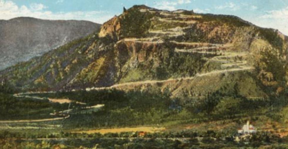
Three years later, the road to the top of the mountain was cut through the zoo to the summit, carved and blasted through the massive granite that makes up the mountain. Fresh breaks in granite expose a white and reflective collection of minerals as seen in this early photo. Now, Spencer was as popular as a man could get, but the residents of the city were not happy with their backdrop sporting this new squiggle running up the face of their prized mountain. The roadbed itself wasn’t as visible as was the newly exposed stone immediately above and below the cut. As you will see on the drive, a cut in a steep hill side will bare granite above the road and create the fill cascading below the road. Picture a 60’ swath of bright and highly reflective stone in the morning light.
He then built the pueblo style Cheyenne Mountain Lodge, nicknamed the Honeymoon Lodge, on top of the mountain at the end of this spectacular zig-zag road. It had a restaurant, a curio shop and four hotel rooms. This was demolished in the 1970’s and replaced with Cloud Camp in 2014. Unfortunately, the upper half of this tenacious road is closed to the public but the lower half is just as special and open for you to explore.
For the flatlanders out there, a switchback is created when a road needs to gain elevation in a restricted amount of space. The “W’s” on the Pikes Peak Highway are a perfect example. Cheyenne Mountain’s switchbacks were named when it first opened in 1925 with such spectacular signage as Sheercliff Loop, Hell Gate, Paradise Trail, The Spiral Shelves, Cloudland Loop, Vista Grand Swing, Multi-Vista Swing and ending at the Devil’s Horns. The truth is it’s a safe road with beautiful twists and turns.
The Cheyenne Mountain Zoo is consistently rated as one of the top zoos in the nation mostly due to its unique mountainside location and the active giraffe program. Above the zoo is a road full of switchbacks that you may drive with the purchase of a zoo ticket. Surprisingly, the majority of the visitors don’t take advantage or are not aware of the option to drive through the zoo and experience this famous road up to the Shrine above.
Start at the zoo’s parking lot. At one time, there was a miniature cog train that connected the zoo to a lakeside depot at the Broadmoor Hotel. This little trail was modeled after the technology that made the Manitou and Pikes Peak Railway possible. Note the worn toothed cog rail that is now used for parking barriers. On display in the north end of the zoo’s parking lot is the custom engine made by Cadillac that was used to power this cog train in the 1950’s. This little white engine is sitting on a piece of the original track location and the tunnel underneath the road still exists. A piece of the raised railroad bed parallels the road just beyond the tunnels opening on the other side of the road.
The physical hiking part of this adventure is at the zoo. After you feed the giraffes and admire the organization’s education and conservation efforts, return to your car and drive to the main gate and present your zoo ticket.
Really, you can drive right through the middle of the zoo.
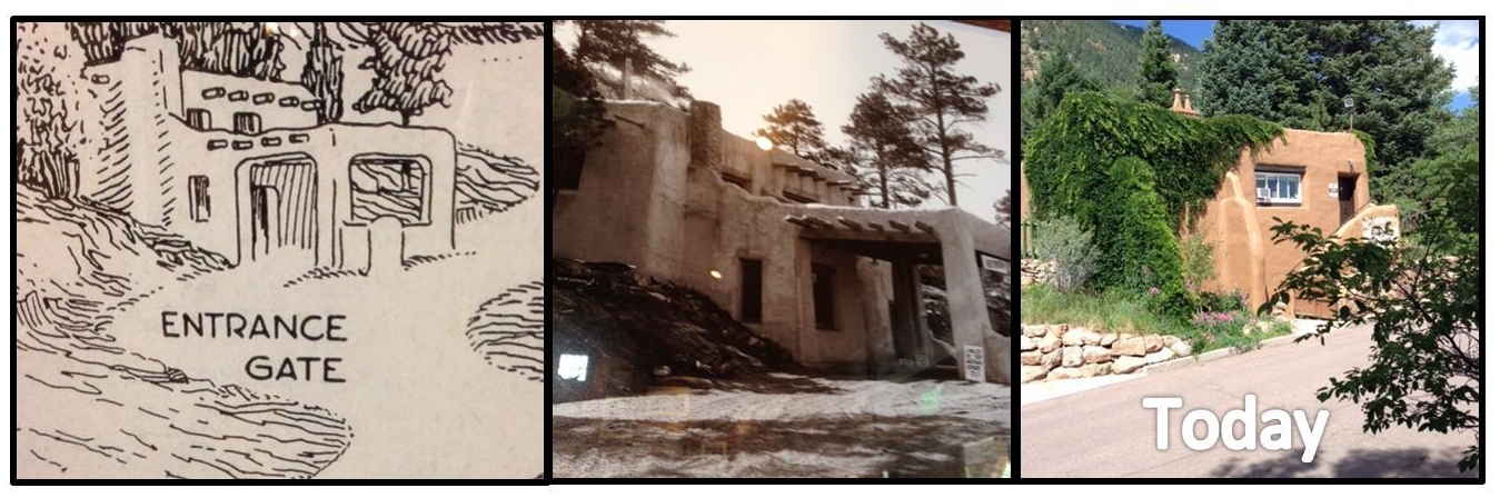
0.0 Reset you odometer at 0.0 when you pass through the iron gates and into the zoo. Immediately to your left is the education office of the zoo. Originally it was a big deal! This inconspicuous building originally had a covered drive attached to it where you could take your new Model A Ford through the zoo and beyond for 25 cents.
Be on the alert for loose children and peacocks meandering about. Parking is not permitted inside the zoo.
0.2 At the top of the zoo, signage will direct you to turn left on the first of many switch backs. If the weather allows open your sunroof as this ride will provide the opportunity to view mountain scenery above your head. Open your windows on your ascent for the sounds of the animals and the chimes from the shrine above. Feel the fresh mountain air. Turn on the map display of your GPS just to watch your icon meander up the winding thread of a road. As you know by now, we are all about the experiences of the journey, not just the destination.
0.3 An automatic chain link gate will open for your vehicle. This gate is meant to keep an escaping animal inside the zoo’s boundary, but more importantly it keeps the mountain’s native wildlife out of the zoo, although an occasional mule deer sneaks through when a car passes. Wave at the people in the chair lift that pass above your head as they wonder how you have the privilege to be on this mountain road. To your left below the chairlift you can see some of the small cages originally used in the early life of the zoo. These ancient cube shaped cages are no longer accessible to the public visiting the zoo but can be seen clearly from the chairlift. No longer in use, their stone and steel wire construction has held up well beyond their usefulness. I’m glad they still exist to illustrate how animal care has progressed.
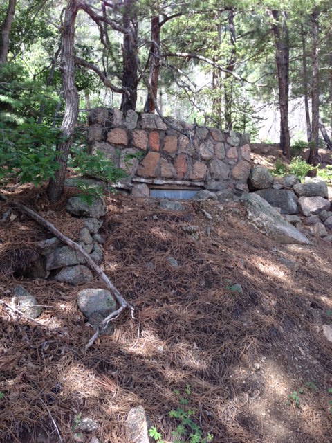
0.6 On your right, just before the switchback you can spot the remnants of a man made bear den. The cage is gone but the face of the tiny building and metal door are visible, partially covered by fallen rock. Mr. Penrose wanted his guests to experience the Colorado Mountains during their brief visit. Imagine seeing a (caged) bear on the way up the road! I suppose the travelers could easily approach the cage and feed it. At the summit lodge he had a similar bear cage at the side of the main staircase leading from the parking lot.
This road is 7 miles long and has 21 switchback turns. It was showcased in Ripley’s Believe It Or Not in 1925 as the most crooked road in the world. (Do I sense Spencer Penrose’s ability to promote?) This new dirt road was able to claim this title because there are 7.5 miles of road inside a 1.25 mile square map grid. I’m sure that once this was published, there were countries on the other side of the world that said “Nice try, America, be we can beat that!” In thick accents of course.
1.3 Hell Gate is a sight to see! Not really, it’s just a small rock pile. This is the longest stretch of road between swich backs, and the right side is open to a view of the city. Only Hell Gate rises above the road level on the right side.
It is unique because it is the only spire of boulders on an otherwise long dropoff on this stretch of road. The most interesting object here is the black power pole that is still standing in place next to Hell’s Gate. This is one of the original lighted utility poles to the summit. Once again I am impressed that these pieces of history were not removed decades ago. On the hillside above you is another pole in the series. Why is it special? Our dear Mr. Penrose couldn’t resist the opportunity to promote this lodge in a way that nobody else would dare to attempt. He drew a line from downtown Colorado Springs to the summit and instructed that 26 iron power poles be installed in the straight line up the face of the mount. He then proceeded to have a street lamp installed at the top of each power pole. I am picturing an “Eat at Joes” feel to his idea. Electric lights were still an exciting concept, but this was too much. Not only was there a reflective scar switch-backing up the mountain face during the day, but now a string of lights pointing to the lodge at night.
What the city’s residents didn’t know at the time was that Mr. Penrose had an aircraft navigation beacon on order but it didn’t arrive in time for the grand opening. Two months later, at the top of the string of lights up the hill, the city was treated to a bright beam of light rotating once every 10 seconds. A lens about the size of a trash can lid was rotated by a motor on the scaffolding attached to the highest point on the lodge. You can see the scaffolding on some of the older photos of the lodge.
1.7 Before the road switches back on itself again, this is a good place to stop and look out over the city below and the mountain above. You are allowed to stop and step out of you vehicle, with caution. Use that parking brake! Although this road was built in 1925 it wasn’t paved until 1966. This chain link fencing was installed in 1925. I had no idea that chain link fencing has been around that long, but it can be seen in a photo of Mr. Penrose’s funeral procession in 1939 inside one of the rooms of the Will Rogers Shrine. The posts are reused railroad rails marked mostly with dates around 1887. It is quite likely that they came from Pikes Peak’s cog railway. The Pikes Peak and Manitou Cog Railway was built in 1889 and purchased by Spencer Penrose in 1925, the same year that this road was built. These rails are buried two thirds underground and one third above. It makes me feel better on the drive up knowing how sturdy they are.
1.8 At the end of this switchback, notice how this rusty granite appears different than the rest of the stone on the mountain. Geologists speculate that this set of Rocky Mountains is actually the third version. The two versions that existed before, known as the Ancestral Rockies, disappeared and reappeared through eons of erosion and upheaval. You are driving up the third version of the mountain range that is about half was through the erosion process. Try to picture these mountains twice as high! The granite at the end of this switchback is different than most of the lighter and younger granite. This switchback is made up of crumbly, yellowish brown granite and was part of the Ancestral Rockies.
On the many hikes that I have led over the years, people will marvel that these boulders appear to have been stacked up, and they really have. These stacked rounded boulders have ridden down the eroding mountains over time, stacked by Mother Nature onto the boulders below.
2.0 This sign for Sheercliff Loop has been around a long, long time. You are entering the Shrines parking lot. Watch your speed as you enter. There are usually mammals crossing the road while taking selfies on the way to and from the walk to the shrine.
You have reached the end of the trail at the Will Rogers Shrine’s parking lot. At the top of the parking lot are a small stable and another switchback as the road continues. Beyond this gate is private access road to Broadmoor’s spectacular and pricy Cloud Camp. Although there are 16 more switchbacks of dirt road beyond the shrine’s parking lot, the remaining road is not open to the public.
You are now at 8,100 feet above sea level and 2,000 feet above Colorado Springs. Climbing the shrine will provide a stretch for your legs and a treat for your eyes. It may also illustrate that oxygen is not as plentiful as you would like. The five stories of stairs will take you past rooms with murals of the history of the Pikes Peak region and a photographic history of Will Rogers. The climb terminates at a breathtaking view from the tiny open air rooftop patio.
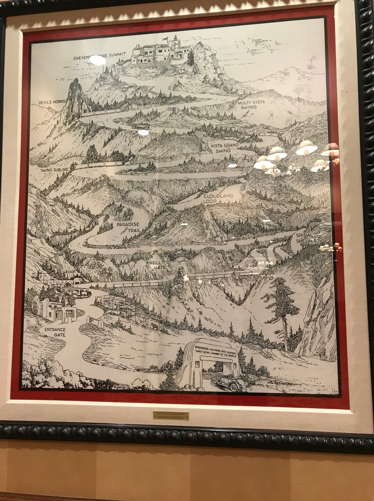
Spencer Penrose, the legendary founder of the Broadmoor Hotel and a premier name in the history of Cripple Creek and Colorado Springs built his Penrose Mausoleum on a prominent point on the side of Cheyenne Mountain. During construction, his wife gently suggested that it would be inappropriate to name a structure this grandiose looming over the city after themselves, and the wise husband listened. The name was changed to “The Shrine of the Sun”. During construction, their polo playing acquaintance, humorist Will Rogers, perished in an Alaskan plane crash. Never one to pass up an opportunity for public interest, Spencer Penrose changed the name to The Will Rogers Shrine of the Sun and a bust of Will Rogers was commissioned to be placed on the trail leading the shrine. Although Will Rogers is not buried there, you may visit the small shrine where Spencer and Julie Penrose are interred along with two business and polo playing associates from his early days. Westminster style chimes in the shrine can be heard for miles below. Interestingly, the granite for this shrine was quarried from a nearby single boulder so that the color of the stones matched exactly. Built of iron, cement and granite, no nails or wood were used. There are brass plaques that denote points of interest viewed from this elevation. My favorite is “Corley Mountain Highway”, now named the Gold Camp Road. It hasn’t been called Corley Mountain Highway for 80 years.
Once you leave the mountain, I suggest a stop an a little known free attraction is Penrose Heritage Museum across the street from the Broadmoor Hotel. Yes, free, but parking in the adjacent garage isn’t. This tiny museum is a wonderful showcase of vehicles associated with the Penrose legacy and cars on display from the annual Pikes Peak Hill Climb. Inside the building to the right of the museum is a large reproduction of a pen-and-ink brochure about the highway above the zoo. Behind this building is the Figure Skating Museum.
As long as you’re here, why not walk around the hotel’s lake? It is another opportunity to admire the architecture and history that is Spencer and Julie Penrose and to appreciate the sound of the chimes from above.

One thought on “Above the Zoo”