

Colorado Springs’ own Eric Swab, the notable author and historian, has generously offered the opportunity to share his recent work on the origins of the Chamberlain Trail. As you can see from my previous post, “Old Gates and New Trails” I have been exploring what will someday be an extensive trail system along the front range. Coincidentally, he had been researching the history of the trail as no one else can. Originally written for TOSC, I present Eric’s article below.
The Chamberlain Trail’s Namesake
by Eric Swab – December 2022
If you ask the Colorado Springs Park and Recreation Department who the Chamberlain Trail is named for, they will tell you Fred W. Chamberlain, because he gave the City 200 acres, 160 acres in 1937 (outlined in green on the map below) and 40 acres in 1938 (outlined in purple). These parcels became part of North Cheyenne Cañon Park. Reason enough to name a trail after him! But did Fred build any trails? At this point we don’t know if he did or not, but we do know his brother Frank did. Frank Clinton Chamberlain (1860-1928) and Frederick Weston Chamberlain (1872-1960) were brothers living in Colorado Springs at the turn of the 20th Century. They were both dentists, and both married to women named Anna. Frank’s wife was Anna D. and Fred’s wife was Anna B.
In 1922, Manly Ormes, author of Mountain Trails of the Pikes Peak Region, wrote to Frank C. Chamberlain, inquiring about his trails. Frank’s response was, “I think the trail to Willard Heights was started twelve, perhaps fifteen years ago. I had expected to put cottages on the road above Point Sublime and pipe water from the spring. I have a permit to cross the rail road and also a deeded right of way from the road crossing over the land which belongs to the Stratton estate near Point Sublime Station. … I built the trail west of the road and wanted to extend the road to Capt. Jack’s place from Willard Heights and so make a circle trip. May do so yet some day.” The “deeded right of way” from the Stratton Estate, dated July 30, 1908, was “for right of way, thirty feet in width, for a wagon road” (outlined in brown on the map).
At the time Frank replied to Manly Ormes, he was living in Los Angeles, California, having moved there in 1919. In his letter, he allowed as how he would, “consider selling the 200 acres I own at Point Sublime for something like $5,000.00.” Was his 200 acres the same 200 acres Fred gave to the City? The records of the General Land Office and the El Paso County Clerk show they were. On December 17, 1906, Walter A. Brown received a patent for his homestead in Section 27 (outlined in green on the map), just northwest of Point Sublime. On September 4, 1907, Brown sold his land to Anna D. Chamberlain, Frank’s wife.
Did she buy Willard Heights? For the answer look at paragraph 18. on panel 10 of Manly Ormes Mountain Trails of the Pikes Peak Region, 1921 edition. Ormes writes, “go to Sesame Canon, go up to the end of the canon to Willard Heights, and take [the] trail along the outer edge of the mountain to Point Sublime on the Cripple Creek Short Line. From this point you can descend by trail abruptly into North Cheyenne Canon; or you can follow north on a trail that runs parallel with railroad, then crosses it and descends via Chamberlain trail to a point on North Cheyenne Canon road near Stratton Park.” (see Ormes map below)
Ormes doesn’t label Willard Heights nor Point Sublime on his map but the current USGS Topo map shows the Penrose Trail running along a ridge from the head of Sesame Canyon to Point Sublime. Surely this is the trail Ormes was describing. When the Penrose Trail reaches Point Sublime it does drop into North Cheyenne Cañon. Looking carefully on the ground at this point, you will see an old trail that heads north parallel to Gold Camp Road (purple trail on map). This trail fades out on a scree slope and a social trail drops to Gold Camp Road.
The point at which Frank Chamberlain had permission to cross the Short Line tracks must be the point at which the current Ladders, The Chutes, and Gold Camp Path trails all come together on Lower Gold Camp Road. Right across the road from this point is another old trail that heads south paralleling the road (not the Captain Morgan’s Trail shown on AllTrails web site). It also fades out before joining the old trail coming north from Point Sublime, however, they must have connected in the past. Of the several trails leading from the crossing point down to the North Cheyenne Cañon road, my choice for the route of Frank C. Chamberlain’s trail is The Chutes. Neither the Gold Camp or South Suburban Reservoirs existed at the time Frank built his trail, so his route may have been totally different.
On the 13th of June, 1925, Frank C. Chamberlain of Los Angeles, California, sold his 200 acres to Fred W. Chamberlain of El Paso County Colorado (green and purple outlines). It is not clear what Fred did with the land between 1925 and 1937, but it is clear the trail from North Cheyenne Cañon road to Point Sublime was already there, as shown on Ormes map, below. It seems appropriate the Chamberlain trail be named after both Frank and Fred.
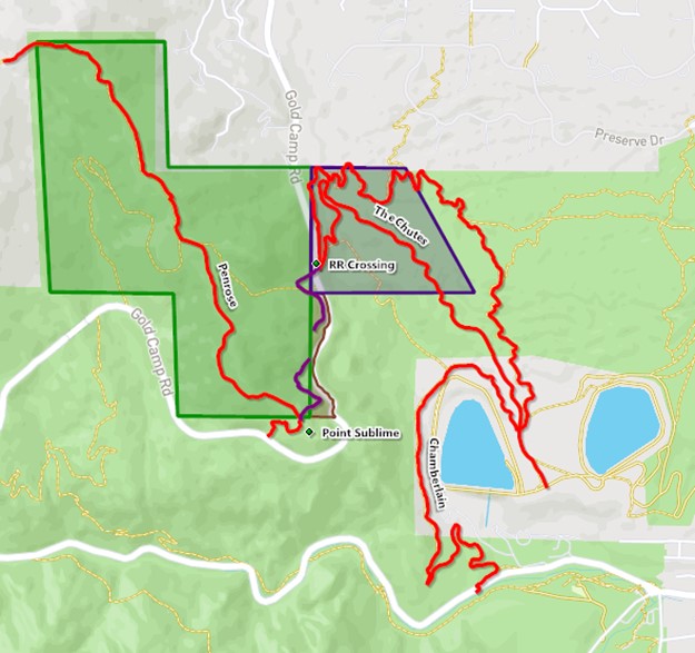
Above: Current map of the Chamberlain and Penrose Trails,
and the abandoned trail from RR Crossing to Point Sublime (in purple).
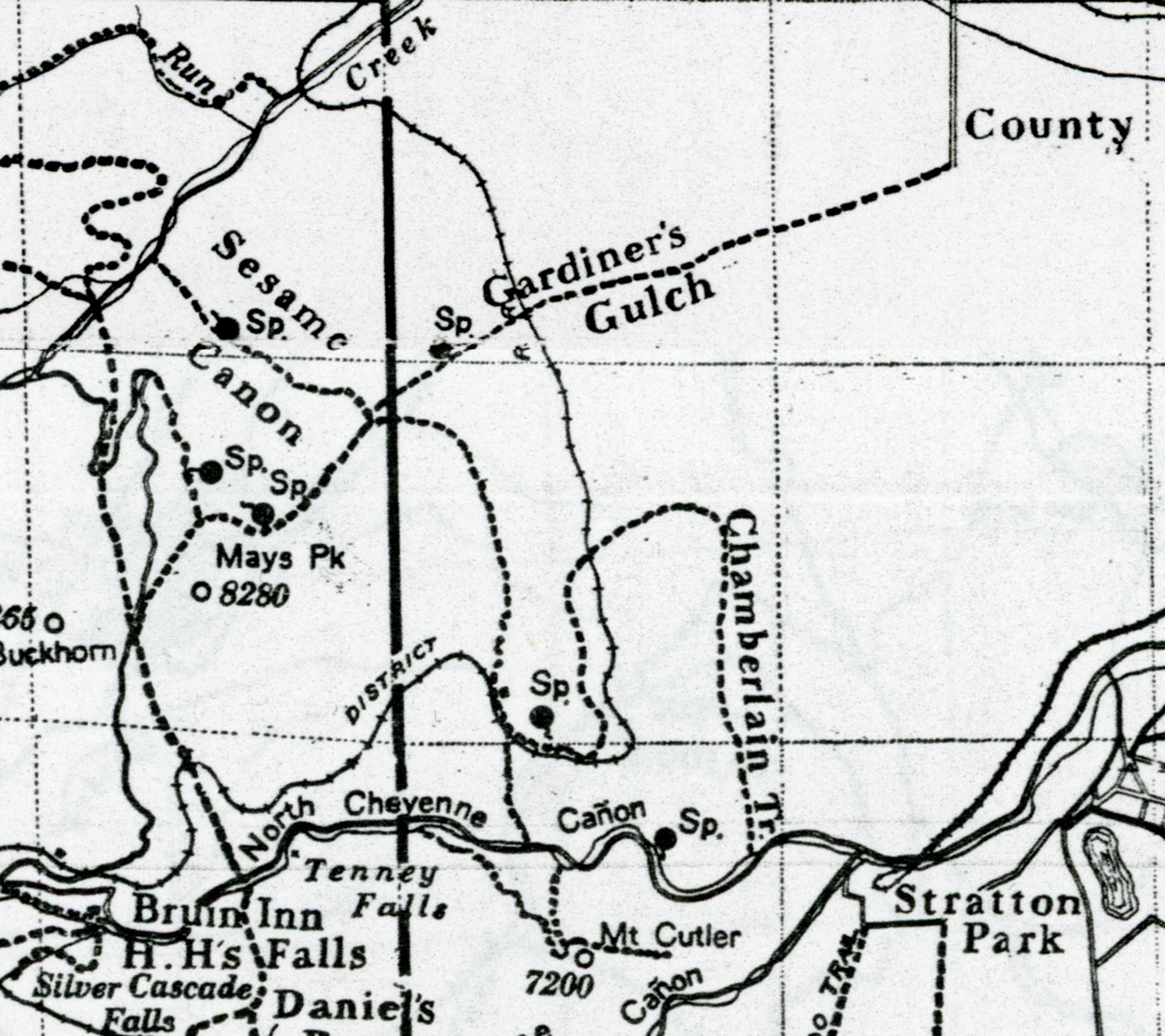
Above: Detail from Manly Ormes’ Mountain Trails of the Pikes Peak Region, 1918 edition.
The lake to the right of “Stratton Park” is the Broadmoor Hotel’s lake.

Eric Swab is the author of Granite Attraction, Stories of the Pikes Peak Highway and Summit. He also has written books about Fred Barr and about the Manitou Incline, available at the Manitou Springs Heritage Center.
