

At the top of the Old Stage Road, as it intersects the Gold Camp Road, you will see caved in tunnel number 7 to the right of the intersection. As a matter of fact, these collapsed tunnels are the reason you must drive up Old Stage Road to get to the Gold Camp Road today. It is quite complicated to figure out how the loops of the railroad ran when you are up there, but we have THE ANSWER below.
At the parking lot for Saint Peter’s Dome (#4 on the map below), there is another closed section of the old railbed. Did you know there is a second tunnel (tunnel 8) nearby that few know about?
The Colorado Springs and Cripple Creek District Railway (CS&CCDR) ran from 1901-1920. This standard gauge railroad was converted to a toll road called the Corley Mountain Highway that ran until 1936. At that point it became a public road.
Interestingly, when all of this was bypassed, the current road actually travels on a small piece of the railroad bed in the opposite direction. We haven’t even started yet and it is getting confusing.
I have had two readers request information on how these abandoned roadbeds and tunnels came about. That is a good question. We will unravel the tangle here.
The railroad ran at a maximum grade of 3.8% and the Old Stage Road is obviously too steep for a train. That is the easiest way to know when you leave one and join the other. At the top of Old Stage Road, where it intersects with the Gold Camp Road, turn right a short distance until it dead ends at the closed tunnel. If you go to the right of the tunnel, there is a gate across the closed portion of the Gold Camp Road. This closed portion runs 7 miles to the parking lot above Helen Hunt Falls.
In the map below, the loop between tunnels number 7 and 8 had been left to nature when the railroad bed was converted to an automobile road in the early 1920’s. That is pretty cool, and fun to explore, until you try to figure out how the railroad ran.

Looking at the map above, Old Stage Road parallels Rock Creek as it climbed to the intersection with the railroad just below tunnel 7.
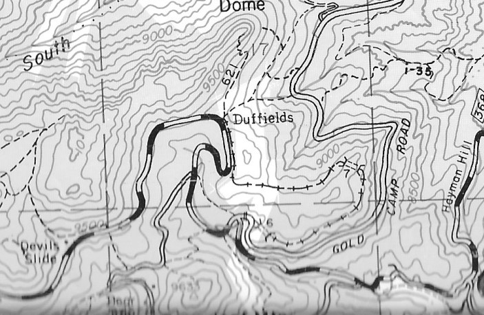
The map below is a detail of the area as it is today, taken from the valuable Pikes Peak Atlas by Robert Ormes and Robert Houdek. The line coming in from the bottom right of the map marked Hayman Hill is the Old Stage Road. The dashed railroad symbol in the loop between the two tunnels is the abandoned roadbed. This piece is overgrown and not accessible to drive. Note that this map calls these same tunnels 6 and 7, not 7 and 8. By bypassing this loop, it shortened this stretch of the road from 2 miles that the train needed to only to 3/4 of a mile to drive.
By comparing the two maps above, it’s still hard to see what happened during the transformation. Below, I have created a map to illustrate the differences.
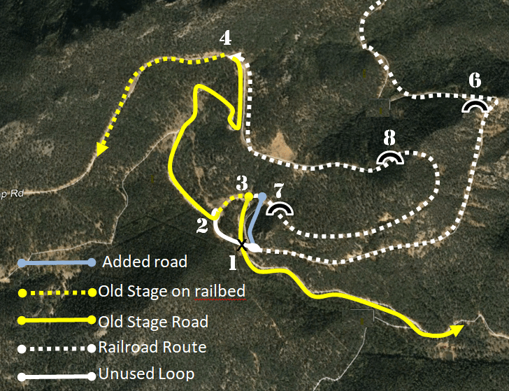
The yellow line is Old Stage Road as it is today. The dashed yellow line is where todays road follows the roadbed. Note the very short dashed yellow line between (2) and (3)? That is where you drive on the railroad bed in the opposite direction than the train traveled.
THE ANSWER: The key to this whole mess is the black X (1) above. The road went under a trestle that is no longer there. The section of railroad bed between (1) and (2) is a piece of a curve that is no longer used. You can still find it on your left (2) as you drive away from the intersection. Walk the curve and see where the trestle ran above the Old Stage Road and joined the closed section of Gold Camp Road. Remnants of the trestle may be seen if you look hard enough. A small connecting road (blue) was added between the gate and the other end of the trestle.
Clear as mud? Really, for this all to make sense, you must drive up there and explore. But then again, that’s what this website is all about!
Read a story in OUT THERE COLORADO about our new book on hiking the Pikes Peak Region and obscure trailside relics.
.

Rocky,
Nice work clearing this up. The section of rail right of way between 1 and 7 was known at the Duffield Loop. Wish I knew more about the Duffield brothers. There is a little bit of the trestle over the Stage road left on both sides of the road. You have to look for it, but its there.
Eric Swab Phone: 719-640-1371 email: eswab@comcast.net
LikeLiked by 1 person
Thank you, Eric, for keeping me straight on my facts! I’ll look for the trestle remnants next time I go up. I have read the Duffield brothers ran a sawmill up there but that’s it.
LikeLike